
Accueil / OHM Vallée du Rhône / Archives cartographiques et topographiques /
Map (Soyons to torrent Turzon, 1846)
349/350
)
)
)
)
)
)
)
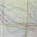
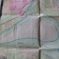
: Plan de l'encaissement du Rhône entre le village de Soyons et le torrent de Turzon. English title: Map of the Rhône river between the village of Soyons and the Turzon torrent.")
Original title (in French): Plan de l'encaissement du Rhône entre le village de Soyons et le torrent de Turzon. English title: Map of the Rhône river between the village of Soyons and the Turzon torrent.
- Auteur
- Bouvier
- Tags
- Fonds/Photographic fund
- Archives Nationales (France) (reference: F/14/6569)
- Contributeurs/Contributors
- Nature de la ressource/Resource type
- Map
- Date
- Période/Period
- 1846
- Commune/Municipality
- Secteur/Sector
- Soyons to torrent Turzon (9 km long)
- Echelle/Scale
- 1/10 000
- Lieu visé ou point de visée/Targeted place or photographer geolocation
- Projet OHM/OHM project
- Complément d'information/Additional information
- Ressource liée/Linked resource
- DOI
- Copyright
- Creative Commons (BY-NC)