
862/1165
)
)
)
)
)
)
)
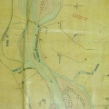
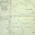
: Plan à joindre au rapport en date de ce jour en réponse à la pétition du Sieur de Jovyac. English title: Plan to be attached to today's report in response to Sieur de Jovyac's petition.")
Original title (in French): Plan à joindre au rapport en date de ce jour en réponse à la pétition du Sieur de Jovyac. English title: Plan to be attached to today's report in response to Sieur de Jovyac's petition.
- Author
- Josserand
- Tags
- Fonds/Photographic fund
- Archives Nationales (France) (reference: F/14/6517)
- Contributeurs/Contributors
- Nature de la ressource/Resource type
- Map
- Date
- Période/Period
- 1849
- Commune/Municipality
- Secteur/Sector
- Le Teil (6 km long)
- Echelle/Scale
- 1/10 000
- Lieu visé ou point de visée/Targeted place or photographer geolocation
- Projet OHM/OHM project
- Complément d'information/Additional information
- Ressource liée/Linked resource
- DOI
- Copyright
- Creative Commons (BY-NC)