
373/1165
)
)
)
)
)
)
)
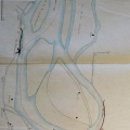
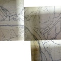
: Plan d'une partie du cours du Rhône à l'appui de l'avant-projet des ouvrages à faire contre ce fleuve à l'entrée de la gorge de Malmouche, près de la maison Faugier, sur une longueur de 1560 m. English title: Plan of part of the Rhône river in support of the preliminary design of the works to be carried out at the entrance to the Malmouche gorge, near the Faugier house, over a length of 1560 m.")
Original title (in French): Plan d'une partie du cours du Rhône à l'appui de l'avant-projet des ouvrages à faire contre ce fleuve à l'entrée de la gorge de Malmouche, près de la maison Faugier, sur une longueur de 1560 m. English title: Plan of part of the Rhône river in support of the preliminary design of the works to be carried out at the entrance to the Malmouche gorge, near the Faugier house, over a length of 1560 m.
- Auteur
- Josserand
- Tags
- Fonds/Photographic fund
- Archives Nationales (France), Archives Départementales du Rhône (reference: F/14/6567, S 1396)
- Contributeurs/Contributors
- Nature de la ressource/Resource type
- Map
- Date
- Période/Period
- 1842
- Commune/Municipality
- Secteur/Sector
- Viviers (2 km long)
- Echelle/Scale
- 1/10 000
- Lieu visé ou point de visée/Targeted place or photographer geolocation
- Projet OHM/OHM project
- Complément d'information/Additional information
- Ressource liée/Linked resource
- DOI
- Copyright
- Creative Commons (BY-NC)
- Make
- Canon
- Model
- Canon PowerShot G9
- DateTimeOriginal
- 2017:12:07 17:01:31
- ApertureFNumber
- f/2.8