
Inicio / OHM Vallée du Rhône / Archives cartographiques et topographiques /
Map (St-Marcel-d'Ardèche to Pont-St-Esprit, 1834)
132/350
)
)
)
)
)
)
)
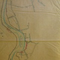
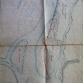
: Plan d'une partie du cours du Rhône relatif à l'établissement d'une digue de défense, avec chemin de halage, en amont du Pont-St-Esprit. English title: Plan of part of the Rhône river related to the establishment of a defensive dyke, with a towpath, upstream of Pont-St-Esprit.")
Original title (in French): Plan d'une partie du cours du Rhône relatif à l'établissement d'une digue de défense, avec chemin de halage, en amont du Pont-St-Esprit. English title: Plan of part of the Rhône river related to the establishment of a defensive dyke, with a towpath, upstream of Pont-St-Esprit.
- Autor
- Bouvier
- Tags
- Fonds/Photographic fund
- Archives Départementales du Rhône (reference: S 1423)
- Contributeurs/Contributors
- Nature de la ressource/Resource type
- Map
- Date
- Période/Period
- 1834
- Commune/Municipality
- Secteur/Sector
- St-Marcel-d'Ardèche to Pont-St-Esprit (6 km long)
- Echelle/Scale
- 1/10 000
- Lieu visé ou point de visée/Targeted place or photographer geolocation
- Projet OHM/OHM project
- Complément d'information/Additional information
- Ressource liée/Linked resource
- DOI
- Copyright
- Creative Commons (BY-NC)