
Inicio / OHM Vallée du Rhône / Archives cartographiques et topographiques /
Map (St-Gilles to Stes-Maries-de-la-Mer, 1847)
159/350
)
)
)
)
)
)
)
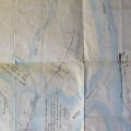
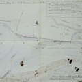
: Plan général du Petit-Rhône entre le Château d'Avignon et le bac du Sauvage, à joindre au projet de réparations à faire aux chaussées du Petit Rhône (...). English title: General plan of the Petit-Rhône river between the Avignon castle and the Sauvage ferry, to be attached to the project of repairs to be made to the Petit-Rhône roadways (...).")
Original title (in French): Plan général du Petit-Rhône entre le Château d'Avignon et le bac du Sauvage, à joindre au projet de réparations à faire aux chaussées du Petit Rhône (...). English title: General plan of the Petit-Rhône river between the Avignon castle and the Sauvage ferry, to be attached to the project of repairs to be made to the Petit-Rhône roadways (...).
- Autor
- Bouvier
- Tags
- Fonds/Photographic fund
- Archives Nationales (France) (reference: S 1453)
- Contributeurs/Contributors
- Nature de la ressource/Resource type
- Map
- Date
- Période/Period
- 1847
- Commune/Municipality
- Secteur/Sector
- St-Gilles to Stes-Maries-de-la-Mer (7 km long)
- Echelle/Scale
- ~ 1/10 000
- Lieu visé ou point de visée/Targeted place or photographer geolocation
- Projet OHM/OHM project
- Complément d'information/Additional information
- Ressource liée/Linked resource
- DOI
- Copyright
- Creative Commons (BY-NC)