
Accueil / OHM Vallée du Rhône / Archives cartographiques et topographiques /
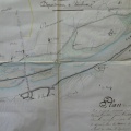
Map (St-Marcel-d'Ardèche to Pont-St-Esprit, 1838)
85/350
)
)
)
)
)
)
)
: Plan des digues du Rhône en construction en amont du Pont-St-Esprit. English title: Plan of the dykes of the Rhône river in construction upstream of Pont-St-Esprit.")
Original title (in French): Plan des digues du Rhône en construction en amont du Pont-St-Esprit. English title: Plan of the dykes of the Rhône river in construction upstream of Pont-St-Esprit.
- Auteur
- Bouvier
- Tags
- Fonds/Photographic fund
- Archives Départementales du Rhône (reference: S 1423)
- Contributeurs/Contributors
- Nature de la ressource/Resource type
- Map
- Date
- Période/Period
- 1838
- Commune/Municipality
- Secteur/Sector
- St-Marcel-d'Ardèche to Pont-St-Esprit (6 km long)
- Echelle/Scale
- 1/5000
- Lieu visé ou point de visée/Targeted place or photographer geolocation
- Projet OHM/OHM project
- Complément d'information/Additional information
- Ressource liée/Linked resource
- DOI
- Copyright
- Creative Commons (BY-NC)
- Make
- Canon
- Model
- Canon PowerShot G9
- DateTimeOriginal
- 2018:12:18 15:31:02
- ApertureFNumber
- f/2.8