
Home / OHM Vallée du Rhône / Archives cartographiques et topographiques /
Map (Aramon to Comps, 1855)
141/350
)
)
)
)
)
)
)
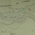
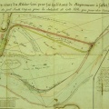
: Projet de défense du territoire du syndicat de Comps. English title: Defence project for the land of the syndicate of Comps.")
Original title (in French): Projet de défense du territoire du syndicat de Comps. English title: Defence project for the land of the syndicate of Comps.
- Author
- Kleitz
- Tags
- Fonds/Photographic fund
- Archives Départementales du Rhône (reference: S 1435)
- Contributeurs/Contributors
- Nature de la ressource/Resource type
- Map
- Date
- Période/Period
- 1855
- Commune/Municipality
- Secteur/Sector
- Aramon to Comps (12 km long)
- Echelle/Scale
- 1/10 000
- Lieu visé ou point de visée/Targeted place or photographer geolocation
- Projet OHM/OHM project
- Complément d'information/Additional information
- 2 maps
- Ressource liée/Linked resource
- DOI
- Copyright
- Creative Commons (BY-NC)
- Make
- Canon
- Model
- Canon PowerShot G9
- DateTimeOriginal
- 2018:12:04 14:48:11
- ApertureFNumber
- f/2.8