
Home / OHM Vallée du Rhône / Archives cartographiques et topographiques /
Map (Cordon to Glandieu, 1843)
256/350
)
)
)
)
)
)
)
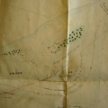
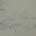
: Application particulière pour les Iles du Chaffard depuis le pont suspendu de Cordon jusqu'au torrent du Glandieu. English title: Special application for the Chaffard islands from the Cordon suspension bridge to the Glandieu torrent.")
Original title (in French): Application particulière pour les Iles du Chaffard depuis le pont suspendu de Cordon jusqu'au torrent du Glandieu. English title: Special application for the Chaffard islands from the Cordon suspension bridge to the Glandieu torrent.
- Author
- O'Brien
- Tags
- Fonds/Photographic fund
- Archives Nationales (France) (reference: F/14/6807)
- Contributeurs/Contributors
- Nature de la ressource/Resource type
- Map
- Date
- Période/Period
- 1843
- Commune/Municipality
- Secteur/Sector
- Cordon to Glandieu (6 km long)
- Echelle/Scale
- 1/20 000
- Lieu visé ou point de visée/Targeted place or photographer geolocation
- Projet OHM/OHM project
- Complément d'information/Additional information
- Ressource liée/Linked resource
- DOI
- Copyright
- Creative Commons (BY-NC)
- Make
- Canon
- Model
- Canon PowerShot G9
- DateTimeOriginal
- 2017:12:08 15:55:42
- ApertureFNumber
- f/4.0