
212/350
)
)
)
)
)
)
)
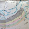
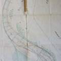
: Plan du cours du Rhône levé par les habitants de Roquemaure à l'effet d'obtenir de SM le rétablissement du port aussi urgent pour la salubrité de cette ville que pour son commerce. English title: Plan of the Rhône river surveyed by the inhabitants of Roquemaure in order to obtain from SM the restoration of the port, as urgent for the health of this city as for its trade.")
Original title (in French): Plan du cours du Rhône levé par les habitants de Roquemaure à l'effet d'obtenir de SM le rétablissement du port aussi urgent pour la salubrité de cette ville que pour son commerce. English title: Plan of the Rhône river surveyed by the inhabitants of Roquemaure in order to obtain from SM the restoration of the port, as urgent for the health of this city as for its trade.
- Auteur
- Guiraud
- Tags
- Fonds/Photographic fund
- Archives Nationales (France) (reference: F/14/6589)
- Contributeurs/Contributors
- Nature de la ressource/Resource type
- Map
- Date
- Période/Period
- 1819
- Commune/Municipality
- Secteur/Sector
- Roquemaure (3 km long)
- Echelle/Scale
- 1/5000
- Lieu visé ou point de visée/Targeted place or photographer geolocation
- Projet OHM/OHM project
- Complément d'information/Additional information
- Ressource liée/Linked resource
- DOI
- Copyright
- Creative Commons (BY-NC)