
1244/10499
)
)
)
)
)
)
)
: Carte des embouchures du Rhône en 1866 indiquant les anciens lits du fleuve abandonnés aujourd'hui. English title: Map of the Rhône mouths in 1866 showing the old riverbeds now abandoned.")
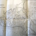
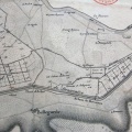
Original title (in French): Carte des embouchures du Rhône en 1866 indiquant les anciens lits du fleuve abandonnés aujourd'hui. English title: Map of the Rhône mouths in 1866 showing the old riverbeds now abandoned.
- Auteur
- Desjardins
- Tags
- Fonds/Photographic fund
- Bibliothèque Nationale de France (reference: Ge-FF.9127)
- Contributeurs/Contributors
- Nature de la ressource/Resource type
- Map
- Date
- Période/Period
- 1866
- Commune/Municipality
- Secteur/Sector
- Beaucaire to the sea (63 km long)
- Echelle/Scale
- 1/125 000
- Lieu visé ou point de visée/Targeted place or photographer geolocation
- Projet OHM/OHM project
- Complément d'information/Additional information
- Ressource liée/Linked resource
- DOI
- Copyright
- Creative Commons (BY-NC)