
2314/10499
)
)
)
)
)
)
)
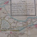
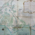
: Carte comparée des Bouches du Rhône anciennes et modernes et des environs des fosses mariennes au IVe s. de notre ère. English title: Comparative map of the old and modern Bouches-du-Rhône and the surroundings of the Marian pits in the 4th c. A.D..")
Original title (in French): Carte comparée des Bouches du Rhône anciennes et modernes et des environs des fosses mariennes au IVe s. de notre ère. English title: Comparative map of the old and modern Bouches-du-Rhône and the surroundings of the Marian pits in the 4th c. A.D..
- Autor
- Desjardins
- Tags
- Fonds/Photographic fund
- Bibliothèque Nationale de France (reference: Ge-FF.9127)
- Contributeurs/Contributors
- Nature de la ressource/Resource type
- Map
- Date
- Période/Period
- 400-1866 ?
- Commune/Municipality
- Secteur/Sector
- Beaucaire to the sea (64 km long)
- Echelle/Scale
- NA
- Lieu visé ou point de visée/Targeted place or photographer geolocation
- Projet OHM/OHM project
- Complément d'information/Additional information
- 2 maps
- Ressource liée/Linked resource
- DOI
- Copyright
- Creative Commons (BY-NC)