
1232/10499
)
)
)
)
)
)
)
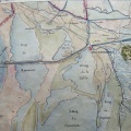
: Carte du cours du Petit Rhône des environs de Fourques à la mer. English title: Map of the Petit Rhône from the Fourques surroundings to the sea.")
Original title (in French): Carte du cours du Petit Rhône des environs de Fourques à la mer. English title: Map of the Petit Rhône from the Fourques surroundings to the sea.
- Auteur
- Ponts & Chaussées
- Tags
- Fonds/Photographic fund
- Bibliothèque Nationale de France (reference: Ge-DD.5537)
- Contributeurs/Contributors
- Nature de la ressource/Resource type
- Map
- Date
- Période/Period
- 1876
- Commune/Municipality
- Secteur/Sector
- Tarascon to the sea (39 km long)
- Echelle/Scale
- 1/40 000
- Lieu visé ou point de visée/Targeted place or photographer geolocation
- Projet OHM/OHM project
- Complément d'information/Additional information
- Sheets 16 and 17
- Ressource liée/Linked resource
- DOI
- Copyright
- Creative Commons (BY-NC)