
1228/10499
)
)
)
)
)
)
)
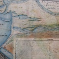
: Carte de la navigation par les étangs et canaux depuis le Rhône jusqu'au canal de Languedoc. English title: Navigation map through the ponds and canals from the Rhône river to the Languedoc canal.")
Original title (in French): Carte de la navigation par les étangs et canaux depuis le Rhône jusqu'au canal de Languedoc. English title: Navigation map through the ponds and canals from the Rhône river to the Languedoc canal.
- Auteur
- NA
- Tags
- Fonds/Photographic fund
- Archives Nationales (France) (reference: CP/F/14/10087/"Canal de Beaucaire". File 4-Piece 7)
- Contributeurs/Contributors
- Nature de la ressource/Resource type
- Map
- Date
- Période/Period
- 1790
- Commune/Municipality
- Secteur/Sector
- Beaucaire to the sea (66 km long)
- Echelle/Scale
- 100 toises
- Lieu visé ou point de visée/Targeted place or photographer geolocation
- Projet OHM/OHM project
- Complément d'information/Additional information
- Ressource liée/Linked resource
- DOI
- Copyright
- Creative Commons (BY-NC)