
2361/10499
)
)
)
)
)
)
)
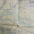
: Nivellement en long sur les deux rives du Rhône. English title: Longitudinal levelling on both banks of the Rhône river.")
Original title (in French): Nivellement en long sur les deux rives du Rhône. English title: Longitudinal levelling on both banks of the Rhône river.

- Author
- Ponts & Chaussées
- Tags
- Fonds/Photographic fund
- Archives Départementales du Rhône (reference: S1356)
- Contributeurs/Contributors
- Nature de la ressource/Resource type
- Long profile
- Date
- Période/Period
- 1869
- Commune/Municipality
- Secteur/Sector
- Seyssel to Lyon (150 km long)
- Echelle/Scale
- 1/10 000
- Lieu visé ou point de visée/Targeted place or photographer geolocation
- Projet OHM/OHM project
- Complément d'information/Additional information
- Long profile indicating water depth and thalweg elevation
- Ressource liée/Linked resource
- DOI
- Copyright
- Creative Commons (BY-NC)
- Make
- NIKON
- Model
- COOLPIX P600
- DateTimeOriginal
- 2016:03:17 10:37:58
- ApertureFNumber
- f/3.3