
12/350
)
)
)
)
)
)
)
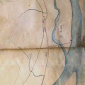
: Plan du cours du Rhône depuis Beaucaire jusqu'à la mer, à joindre au rapport sur les réclamations de la commune de Beaucaire (...). English title: Plan of the Rhône river from Beaucaire to the sea, to be attached to the report on the claims of Beaucaire (...).")
Original title (in French): Plan du cours du Rhône depuis Beaucaire jusqu'à la mer, à joindre au rapport sur les réclamations de la commune de Beaucaire (...). English title: Plan of the Rhône river from Beaucaire to the sea, to be attached to the report on the claims of Beaucaire (...).
- Auteur
- Perrier
- Tags
- Fonds/Photographic fund
- Archives Nationales (France) (reference: F/14/6590)
- Contributeurs/Contributors
- Nature de la ressource/Resource type
- Map
- Date
- Période/Period
- 1844
- Commune/Municipality
- Secteur/Sector
- Beaucaire to the sea (65 km long)
- Echelle/Scale
- ~ 1/150 000
- Lieu visé ou point de visée/Targeted place or photographer geolocation
- Projet OHM/OHM project
- Complément d'information/Additional information
- Ressource liée/Linked resource
- DOI
- Copyright
- Creative Commons (BY-NC)