
1217/10499
)
)
)
)
)
)
)
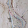
: Plan général de la rive droite du cours du Rhône depuis Limony, jusqu'au pont de Saint-Just. Troisième feuille de Meisse à St-Just. English title: General map of the right bank of the Rhône river from Limony to the St-Just bridge. Third sheet from Meisse to Saint-Just.")
Original title (in French): Plan général de la rive droite du cours du Rhône depuis Limony, jusqu'au pont de Saint-Just. Troisième feuille de Meisse à St-Just. English title: General map of the right bank of the Rhône river from Limony to the St-Just bridge. Third sheet from Meisse to Saint-Just.
- Auteur
- Ponts & Chaussées
- Tags
- Fonds/Photographic fund
- Archives Nationales (France) (reference: CP/F/14/10074/1/B/piece35)
- Contributeurs/Contributors
- Nature de la ressource/Resource type
- Map
- Date
- Période/Period
- 1835
- Commune/Municipality
- Secteur/Sector
- Meysse to St Just (40 km long)
- Echelle/Scale
- 1/10 000
- Lieu visé ou point de visée/Targeted place or photographer geolocation
- Projet OHM/OHM project
- Complément d'information/Additional information
- Not the nature of bars and banks. Right bank only
- Ressource liée/Linked resource
- DOI
- Copyright
- Creative Commons (BY-NC)