Bienvenue dans la photothèque du Laboratoire d'Excellence "Dispositif de Recherche Interdisciplinaire sur les Interactions Hommes-Milieux" (DRIIHM) composé de 13 Observatoires Hommes-Milieux.

Welcome to the photo library of the "Device for Interdisciplinary Research on Human-environments Interactions" (DRIIHM) Laboratory of Excellence.

[ arrêter le diaporama ]

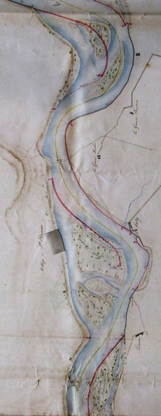
Map (St-Marcel-d'Ardèche to Barbentane , 1834)

504.jpg Map (St Rambert to Pont-St-Esprit, 1833)MiniaturesMap (Meysse to St Just, 1835)Map (St Rambert to Pont-St-Esprit, 1833)MiniaturesMap (Meysse to St Just, 1835)Map (St Rambert to Pont-St-Esprit, 1833)MiniaturesMap (Meysse to St Just, 1835)Map (St Rambert to Pont-St-Esprit, 1833)MiniaturesMap (Meysse to St Just, 1835)Map (St Rambert to Pont-St-Esprit, 1833)MiniaturesMap (Meysse to St Just, 1835)Map (St Rambert to Pont-St-Esprit, 1833)MiniaturesMap (Meysse to St Just, 1835)

Original title (in French): Plan général de la partie du cours du Rhône qui limite les départements du Gard et du Vaucluse, sur lequel on a tracé en rouge les digues et les perrés à exécuter pour encaisser le fleuve et assurer la continuité du chemin de halage. English title: General plan of the part of the Rhône river dividing the departments of Gard and Vaucluse, on which the dykes and ripraps to be built to rectify the river and ensure the continuity of the towpath have been drawn in red.