
Accueil / OHM Vallée du Rhône / Cartographic & topographic archives /
Map (St-Marcel-d'Ardèche to Barbentane , 1834)
10/350
)
)
)
)
)
)
)
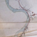
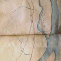
: Plan général de la partie du cours du Rhône qui limite les départements du Gard et du Vaucluse, sur lequel on a tracé en rouge les digues et les perrés à exécuter pour encaisser le fleuve et assurer la continuité du chemin de halage. English title: General plan of the part of the Rhône river dividing the departments of Gard and Vaucluse, on which the dykes and ripraps to be built to rectify the river and ensure the continuity of the towpath have been drawn in red.")
Original title (in French): Plan général de la partie du cours du Rhône qui limite les départements du Gard et du Vaucluse, sur lequel on a tracé en rouge les digues et les perrés à exécuter pour encaisser le fleuve et assurer la continuité du chemin de halage. English title: General plan of the part of the Rhône river dividing the departments of Gard and Vaucluse, on which the dykes and ripraps to be built to rectify the river and ensure the continuity of the towpath have been drawn in red.
- Auteur
- Bouvier
- Tags
- Fonds/Photographic fund
- Archives Nationales (France) (reference: CP/F/14/10074/2/piece4)
- Contributeurs/Contributors
- Nature de la ressource/Resource type
- Map
- Date
- Période/Period
- 1834
- Commune/Municipality
- Secteur/Sector
- St-Marcel-d'Ardèche to Barbentane (62 km long)
- Echelle/Scale
- 1/10 000
- Lieu visé ou point de visée/Targeted place or photographer geolocation
- Projet OHM/OHM project
- Complément d'information/Additional information
- Ressource liée/Linked resource
- DOI
- Copyright
- Creative Commons (BY-NC)