
1282/10499
)
)
)
)
)
)
)
: Plan du cours du Rhône depuis Seyssel jusqu'à Pierre-Châtel sur le territoire de Virignin, ainsi que les communes avoisinantes. English title: Map of the Rhône river from Seyssel to Pierre-Châtel on the territory of Virignin and neighbouring towns.")
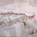
Original title (in French): Plan du cours du Rhône depuis Seyssel jusqu'à Pierre-Châtel sur le territoire de Virignin, ainsi que les communes avoisinantes. English title: Map of the Rhône river from Seyssel to Pierre-Châtel on the territory of Virignin and neighbouring towns.
- Auteur
- NA
- Tags
- Fonds/Photographic fund
- Archives Départementales de l'Ain (reference: 100Fi 67)
- Contributeurs/Contributors
- Nature de la ressource/Resource type
- Map
- Date
- Période/Period
- ~ 1750
- Commune/Municipality
- Secteur/Sector
- Seyssel to Virignin (34 km long)
- Echelle/Scale
- Toises
- Lieu visé ou point de visée/Targeted place or photographer geolocation
- Projet OHM/OHM project
- Complément d'information/Additional information
- This map may have been surveyed after the Sardinian Maps of 1738 and before 1760 because 'lateral lines' from 1760 are not visible everywhere
- Ressource liée/Linked resource
- DOI
- Copyright
- Creative Commons (BY-NC)
- Make
- Canon
- Model
- Canon PowerShot G9
- DateTimeOriginal
- 2017:04:14 01:57:03
- ApertureFNumber
- f/2.8