
1281/10499
)
)
)
)
)
)
)
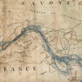
: Plan topographique du camp de Sathonay et de ses environs. English title: Topographical map of the Sathonay camp and its surroundings.")
Original title (in French): Plan topographique du camp de Sathonay et de ses environs. English title: Topographical map of the Sathonay camp and its surroundings.
- Auteur
- Bonnaix
- Tags
- Fonds/Photographic fund
- Bibliothèque Nationale de France (reference: Ge-C.6652)
- Contributeurs/Contributors
- Nature de la ressource/Resource type
- Map
- Date
- Période/Period
- 1875
- Commune/Municipality
- Secteur/Sector
- Nievroz to Irigny (31 km long)
- Echelle/Scale
- 1/40 000
- Lieu visé ou point de visée/Targeted place or photographer geolocation
- Projet OHM/OHM project
- Complément d'information/Additional information
- Downloaded from: gallica.bnf.fr
- Ressource liée/Linked resource
- DOI
- Copyright
- Creative Commons (BY-NC)