
1280/10499
)
)
)
)
)
)
)
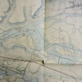
: Le Rhône : frontière entre le royaume de France et le duché de Savoie. English title: The Rhône river: border between the Kingdom of France and the Duchy of Savoy.")
Original title (in French): Le Rhône : frontière entre le royaume de France et le duché de Savoie. English title: The Rhône river: border between the Kingdom of France and the Duchy of Savoy.
- Auteur
- Corefa
- Tags
- Fonds/Photographic fund
- Archives Départementales de la Savoie (reference: 1Fi 77)
- Contributeurs/Contributors
- Nature de la ressource/Resource type
- Map
- Date
- Période/Period
- 1831
- Commune/Municipality
- Secteur/Sector
- Cressin to St-Genix-sur-Guiers (29 km long)
- Echelle/Scale
- 1/14 400
- Lieu visé ou point de visée/Targeted place or photographer geolocation
- Projet OHM/OHM project
- Complément d'information/Additional information
- Ressource liée/Linked resource
- DOI
- Copyright
- Creative Commons (BY-NC)