
2129/10499
)
)
)
)
)
)
)
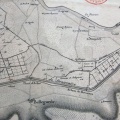
: Plan général indiquant l'emplacement des travaux et les limites du périmètre des propriétés à comprendre dans le syndicat. English title: General plan showing the location of the works and the perimeter limits of the properties to be included in the syndicate.")
Original title (in French): Plan général indiquant l'emplacement des travaux et les limites du périmètre des propriétés à comprendre dans le syndicat. English title: General plan showing the location of the works and the perimeter limits of the properties to be included in the syndicate.
- Autor
- Kleitz
- Tags
- Fonds/Photographic fund
- Archives Nationales (France) (reference: F/14/6569)
- Contributeurs/Contributors
- Nature de la ressource/Resource type
- Map
- Date
- Période/Period
- 1859
- Commune/Municipality
- Secteur/Sector
- Tain (2 km long)
- Echelle/Scale
- 1/5000
- Lieu visé ou point de visée/Targeted place or photographer geolocation
- Projet OHM/OHM project
- Complément d'information/Additional information
- Ressource liée/Linked resource
- DOI
- Copyright
- Creative Commons (BY-NC)
- Make
- Canon
- Model
- Canon PowerShot G9
- DateTimeOriginal
- 2017:12:08 12:09:37
- ApertureFNumber
- f/2.8