
8186/10499
)
)
)
)
)
)
)
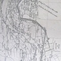
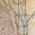
: Plan du Rhône et de ses deux rives, aux abords de la digue de la Moraz. English title: Map of the Rhône river and its two banks near the Moraz dyke.")
Original title (in French): Plan du Rhône et de ses deux rives, aux abords de la digue de la Moraz. English title: Map of the Rhône river and its two banks near the Moraz dyke.
- Auteur
- Thiollière
- Tags
- Fonds/Photographic fund
- Archives Nationales (France) (reference: F/14/6502)
- Contributeurs/Contributors
- Nature de la ressource/Resource type
- Map
- Date
- Période/Period
- 1849
- Commune/Municipality
- Secteur/Sector
- Anglefort (3 km long)
- Echelle/Scale
- 1/10 000
- Lieu visé ou point de visée/Targeted place or photographer geolocation
- Projet OHM/OHM project
- Complément d'information/Additional information
- Ressource liée/Linked resource
- DOI
- Copyright
- Creative Commons (BY-NC)