
2229/10499
)
)
)
)
)
)
)
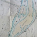
: Projet de construction d'une digue le long des îles de Cruas et de Miraval. English title: Dyke construction project along Cruas and Miraval islands.")
Original title (in French): Projet de construction d'une digue le long des îles de Cruas et de Miraval. English title: Dyke construction project along Cruas and Miraval islands.
- Author
- Josserand
- Tags
- Fonds/Photographic fund
- Archives Départementales du Rhône (reference: S 1344)
- Contributeurs/Contributors
- Nature de la ressource/Resource type
- Map
- Date
- Période/Period
- 1848
- Commune/Municipality
- Secteur/Sector
- Le Pouzin to Meysse (17,5 km long)
- Echelle/Scale
- 1/10 000
- Lieu visé ou point de visée/Targeted place or photographer geolocation
- Projet OHM/OHM project
- Complément d'information/Additional information
- Ressource liée/Linked resource
- DOI
- Copyright
- Creative Commons (BY-NC)