
6416/10499
)
)
)
)
)
)
)
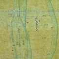
: Etude de l'amélioration du bras d'Avignon. Coupure dans l'Ile d'Oiselet. English title: Study of the improvement of the Avignon channel. Rectification of the Oiselet island.")
Original title (in French): Etude de l'amélioration du bras d'Avignon. Coupure dans l'Ile d'Oiselet. English title: Study of the improvement of the Avignon channel. Rectification of the Oiselet island.
- Author
- Surell
- Tags
- Fonds/Photographic fund
- Archives Départementales du Rhône (reference: S 1345)
- Contributeurs/Contributors
- Nature de la ressource/Resource type
- Map
- Date
- Période/Period
- 1848
- Commune/Municipality
- Secteur/Sector
- Roquemaure to Avignon (11,5 km long)
- Echelle/Scale
- 1/10 000
- Lieu visé ou point de visée/Targeted place or photographer geolocation
- Projet OHM/OHM project
- Complément d'information/Additional information
- Ressource liée/Linked resource
- DOI
- Copyright
- Creative Commons (BY-NC)
- Make
- Canon
- Model
- Canon PowerShot G9
- DateTimeOriginal
- 2018:12:04 11:40:18
- ApertureFNumber
- f/2.8