
2094/10499
)
)
)
)
)
)
)
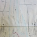
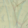
: Projet de régularisation du bras d'Avignon sur une longueur de 970 m. English title: Project for the regularisation of the Avignon channel over a length of 970 m.")
Original title (in French): Projet de régularisation du bras d'Avignon sur une longueur de 970 m. English title: Project for the regularisation of the Avignon channel over a length of 970 m.
- Auteur
- Aymard
- Tags
- Fonds/Photographic fund
- Archives Départementales du Rhône (reference: S 1434, S 1435)
- Contributeurs/Contributors
- Nature de la ressource/Resource type
- Map/Bathymetry
- Date
- Période/Period
- 1853
- Commune/Municipality
- Secteur/Sector
- Avignon (10,5 km long)
- Echelle/Scale
- 1/10 000, 1/2000
- Lieu visé ou point de visée/Targeted place or photographer geolocation
- Projet OHM/OHM project
- Complément d'information/Additional information
- 2 general maps and 1 detailed map
- Ressource liée/Linked resource
- DOI
- Copyright
- Creative Commons (BY-NC)
- Make
- Canon
- Model
- Canon PowerShot G9
- DateTimeOriginal
- 2018:12:04 10:54:53
- ApertureFNumber
- f/2.8