
2254/10499
)
)
)
)
)
)
)
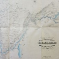
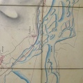
: Plan du tracé entre Letornel et Genève. English title: Map of the route between Letornel and Geneva.")
Original title (in French): Plan du tracé entre Letornel et Genève. English title: Map of the route between Letornel and Geneva.
- Author
- Ponts & Chaussées
- Tags
- Fonds/Photographic fund
- Archives Départementales du Rhône (reference: S 1355)
- Contributeurs/Contributors
- Nature de la ressource/Resource type
- Map
- Date
- Période/Period
- 1846
- Commune/Municipality
- Secteur/Sector
- Genève to Letornel (22 km long)
- Echelle/Scale
- 1/10 000
- Lieu visé ou point de visée/Targeted place or photographer geolocation
- Projet OHM/OHM project
- Complément d'information/Additional information
- Ressource liée/Linked resource
- DOI
- Copyright
- Creative Commons (BY-NC)
- Make
- Canon
- Model
- Canon PowerShot G9
- DateTimeOriginal
- 2018:10:02 07:21:42
- ApertureFNumber
- f/2.8