
8425/10499
)
)
)
)
)
)
)
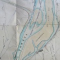
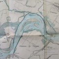
: Défense de la rive droite du Rhône entre l'île Poncet et l'embouchure du Gland. English title: Defence of the right bank of the Rhône river between Poncet island and the Gland confluence.")
Original title (in French): Défense de la rive droite du Rhône entre l'île Poncet et l'embouchure du Gland. English title: Defence of the right bank of the Rhône river between Poncet island and the Gland confluence.
- Auteur
- Thiollière
- Tags
- Fonds/Photographic fund
- Archives Départementales du Rhône (reference: 3959 W 1674)
- Contributeurs/Contributors
- Nature de la ressource/Resource type
- Map
- Date
- Période/Period
- 1855
- Commune/Municipality
- Secteur/Sector
- Cordon to Evieu (9 km long)
- Echelle/Scale
- 1/10 000
- Lieu visé ou point de visée/Targeted place or photographer geolocation
- Projet OHM/OHM project
- Complément d'information/Additional information
- Ressource liée/Linked resource
- DOI
- Copyright
- Creative Commons (BY-NC)
- Make
- Canon
- Model
- Canon PowerShot G9
- DateTimeOriginal
- 2018:10:02 09:01:31
- ApertureFNumber
- f/2.8