
3850/10499
)
)
)
)
)
)
)
: Projet de défense contre les eaux du Rhône, de la plaine et de la ville d'Avignon. English title: Project for defence against the Rhône floods in the plain and city of Avignon.")
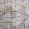
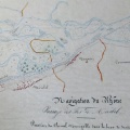
Original title (in French): Projet de défense contre les eaux du Rhône, de la plaine et de la ville d'Avignon. English title: Project for defence against the Rhône floods in the plain and city of Avignon.
- Auteur
- Bouvier
- Tags
- Fonds/Photographic fund
- Archives Départementales du Rhône (reference: S 1422)
- Contributeurs/Contributors
- Nature de la ressource/Resource type
- Map
- Date
- Période/Period
- 1848
- Commune/Municipality
- Secteur/Sector
- Sorgues to Avignon (11 km long)
- Echelle/Scale
- 1/10 000
- Lieu visé ou point de visée/Targeted place or photographer geolocation
- Projet OHM/OHM project
- Complément d'information/Additional information
- Photos of the upstream and downstream ends
- Ressource liée/Linked resource
- DOI
- Copyright
- Creative Commons (BY-NC)
- Make
- Canon
- Model
- Canon PowerShot G9
- DateTimeOriginal
- 2018:10:02 08:12:57
- ApertureFNumber
- f/2.8