
8387/10499
)
)
)
)
)
)
)
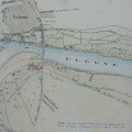
: Plan du syndicat à établir au quartier de l'Ilette territoire de Vallabrègues rive droite du Rhône. English title: Map of the syndicate to be established in the Ilette district of Vallabrègues on the right bank of the Rhône river.")
Original title (in French): Plan du syndicat à établir au quartier de l'Ilette territoire de Vallabrègues rive droite du Rhône. English title: Map of the syndicate to be established in the Ilette district of Vallabrègues on the right bank of the Rhône river.

- Autor
- Bouvier
- Tags
- Fonds/Photographic fund
- Archives Nationales (France) (reference: F/14/6584)
- Contributeurs/Contributors
- Nature de la ressource/Resource type
- Map
- Date
- Période/Period
- 1844
- Commune/Municipality
- Secteur/Sector
- Vallabrègues (11 km long)
- Echelle/Scale
- 1/10 000
- Lieu visé ou point de visée/Targeted place or photographer geolocation
- Projet OHM/OHM project
- Complément d'information/Additional information
- 2 maps
- Ressource liée/Linked resource
- DOI
- Copyright
- Creative Commons (BY-NC)
- Make
- Canon
- Model
- Canon PowerShot G9
- DateTimeOriginal
- 2018:04:11 07:10:13
- ApertureFNumber
- f/4.0