
3699/10499
)
)
)
)
)
)
)
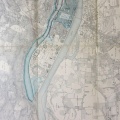
: Ouvrages à exécuter à l'entrée du bras de Villeneuve pour assurer la navigation dans celui d'Avignon. English title: Works to be carried out at the entrance of the Villeneuve channel to ensure navigation in the Avignon channel.")
Original title (in French): Ouvrages à exécuter à l'entrée du bras de Villeneuve pour assurer la navigation dans celui d'Avignon. English title: Works to be carried out at the entrance of the Villeneuve channel to ensure navigation in the Avignon channel.
- Autor
- Ponts & Chaussées
- Tags
- Fonds/Photographic fund
- Archives Départementales du Rhône (reference: S 1426)
- Contributeurs/Contributors
- Nature de la ressource/Resource type
- Map
- Date
- Période/Period
- 1854
- Commune/Municipality
- Secteur/Sector
- Roquemaure to Avignon (19,5 km long)
- Echelle/Scale
- 1/10 000
- Lieu visé ou point de visée/Targeted place or photographer geolocation
- Projet OHM/OHM project
- Complément d'information/Additional information
- Ressource liée/Linked resource
- DOI
- Copyright
- Creative Commons (BY-NC)