
138/350
)
)
)
)
)
)
)
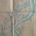
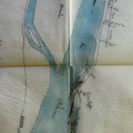
: Plan à l'appui du projet des ouvrages à faire pour terminer la réparation des avaries occasionnées aux digues de Rochemaure, dites de Chabreyron et de la Baraque, par les crues du 27 septembre 1842 et 3 novembre 1843. English title: Plan in support of the project of the works to be done to complete the repair of the damage caused to the dykes of Rochemaure, known as Chabreyron and La Baraque, by the floods of September 27, 1842 and November 3, 1843.")
Original title (in French): Plan à l'appui du projet des ouvrages à faire pour terminer la réparation des avaries occasionnées aux digues de Rochemaure, dites de Chabreyron et de la Baraque, par les crues du 27 septembre 1842 et 3 novembre 1843. English title: Plan in support of the project of the works to be done to complete the repair of the damage caused to the dykes of Rochemaure, known as Chabreyron and La Baraque, by the floods of September 27, 1842 and November 3, 1843.
- Autor
- Josserand
- Tags
- Fonds/Photographic fund
- Archives Départementales du Rhône (reference: S 1409, 3959 W 1680)
- Contributeurs/Contributors
- Nature de la ressource/Resource type
- Map
- Date
- Période/Period
- 1844-1845
- Commune/Municipality
- Secteur/Sector
- Ancone (4 km long)
- Echelle/Scale
- 1/10 000
- Lieu visé ou point de visée/Targeted place or photographer geolocation
- Projet OHM/OHM project
- Complément d'information/Additional information
- 3 maps
- Ressource liée/Linked resource
- DOI
- Copyright
- Creative Commons (BY-NC)