
157/350
)
)
)
)
)
)
)
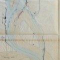
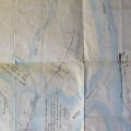
: Plan général d'une partie du cours du Rhône en amont et en aval des rochers de Tête-Noire. English title: General plan of part of the Rhône river upstream and downstream of the Tête-Noire rocks.")
Original title (in French): Plan général d'une partie du cours du Rhône en amont et en aval des rochers de Tête-Noire. English title: General plan of part of the Rhône river upstream and downstream of the Tête-Noire rocks.
- Autor
- Ponts & Chaussées
- Tags
- Fonds/Photographic fund
- Archives Départementales du Rhône (reference: S 1395)
- Contributeurs/Contributors
- Nature de la ressource/Resource type
- Map
- Date
- Période/Period
- 1842
- Commune/Municipality
- Secteur/Sector
- Meysse (3 km long)
- Echelle/Scale
- 1/10 000
- Lieu visé ou point de visée/Targeted place or photographer geolocation
- Projet OHM/OHM project
- Complément d'information/Additional information
- Ressource liée/Linked resource
- DOI
- Copyright
- Creative Commons (BY-NC)