
Início / OHM Vallée du Rhône / Archives cartographiques et topographiques /
Map (Bourg-St-Andéol, 1846-1847)
216/350
)
)
)
)
)
)
)
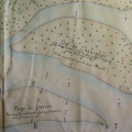
: Plan général des travaux à exécuter pour l'amélioration de la navigation et la défense des rives entre le pont de Bourg-St-Andéol et ceui de Pont-St-Esprit. English title: General plan of the works to be carried out for navigation improvement and bank defence between the bridge of Bourg-St-Andéol and Pont-St-Esprit.")
Original title (in French): Plan général des travaux à exécuter pour l'amélioration de la navigation et la défense des rives entre le pont de Bourg-St-Andéol et ceui de Pont-St-Esprit. English title: General plan of the works to be carried out for navigation improvement and bank defence between the bridge of Bourg-St-Andéol and Pont-St-Esprit.

- Autor
- Bouvier
- Tags
- Fonds/Photographic fund
- Archives Nationales (France) (reference: F/14/6778)
- Contributeurs/Contributors
- Nature de la ressource/Resource type
- Map
- Date
- Période/Period
- 1846-1847
- Commune/Municipality
- Secteur/Sector
- Bourg-St-Andéol (13 km long)
- Echelle/Scale
- 1/10 000
- Lieu visé ou point de visée/Targeted place or photographer geolocation
- Projet OHM/OHM project
- Complément d'information/Additional information
- 2 maps
- Ressource liée/Linked resource
- DOI
- Copyright
- Creative Commons (BY-NC)
- Make
- Canon
- Model
- Canon PowerShot G9
- DateTimeOriginal
- 2018:04:10 04:15:13
- ApertureFNumber
- f/4.0