
Inicio / OHM Vallée du Rhône / Archives cartographiques et topographiques /
Map/Bathymetry (Ilot Champfort, 1859)
60/350
)
)
)
)
)
)
)
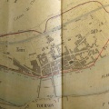
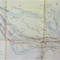
: Plantations faites sans autorisation par le Sr Revol sur un gravier du Rhône. English title: Plantations made without authorization by Sr Revol on a gravel bar of the Rhône river.")
Original title (in French): Plantations faites sans autorisation par le Sr Revol sur un gravier du Rhône. English title: Plantations made without authorization by Sr Revol on a gravel bar of the Rhône river.
- Autor
- Kleitz
- Tags
- Fonds/Photographic fund
- Archives Nationales (France) (reference: F/14/6569)
- Contributeurs/Contributors
- Nature de la ressource/Resource type
- Map/Bathymetry
- Date
- Période/Period
- 1859
- Commune/Municipality
- Secteur/Sector
- Ilot Champfort (2 km long)
- Echelle/Scale
- 1/2500
- Lieu visé ou point de visée/Targeted place or photographer geolocation
- Projet OHM/OHM project
- Complément d'information/Additional information
- Ressource liée/Linked resource
- DOI
- Copyright
- Creative Commons (BY-NC)
- Make
- Canon
- Model
- Canon PowerShot G9
- DateTimeOriginal
- 2017:12:08 12:21:37
- ApertureFNumber
- f/2.8