
111/350
)
)
)
)
)
)
)
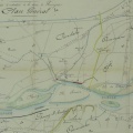
: Construction d'une chaussée insubmersible de 2581,40 m de longueur sur le territoire de Vallergue entre la chaussée de l'Hers et celle du Taleur. English title: Construction of a 2,581.40 m long unsubmersible roadway on Vallergue, between the Hers and Taleur roadways.")
Original title (in French): Construction d'une chaussée insubmersible de 2581,40 m de longueur sur le territoire de Vallergue entre la chaussée de l'Hers et celle du Taleur. English title: Construction of a 2,581.40 m long unsubmersible roadway on Vallergue, between the Hers and Taleur roadways.
- Auteur
- Bouvier
- Tags
- Fonds/Photographic fund
- Archives Nationales (France) (reference: F/14/6586)
- Contributeurs/Contributors
- Nature de la ressource/Resource type
- Map
- Date
- Période/Period
- 1843
- Commune/Municipality
- Secteur/Sector
- Roquemaure (12 km long)
- Echelle/Scale
- 1/15 000
- Lieu visé ou point de visée/Targeted place or photographer geolocation
- Projet OHM/OHM project
- Complément d'information/Additional information
- Ressource liée/Linked resource
- DOI
- Copyright
- Creative Commons (BY-NC)