
Accueil / OHM Vallée du Rhône / Archives cartographiques et topographiques /
Map (Lyon to Donzère, 1845)
148/350
)
)
)
)
)
)
)
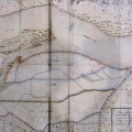
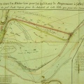
: Plan général du cours du Rhône depuis le confluent de la Saône jusqu'au robinet de Donzère. English title: General map of the Rhône river from the Saône confluence to the Robinet bridge at Donzère .")
Original title (in French): Plan général du cours du Rhône depuis le confluent de la Saône jusqu'au robinet de Donzère. English title: General map of the Rhône river from the Saône confluence to the Robinet bridge at Donzère .
- Auteur
- Josserand
- Tags
- Fonds/Photographic fund
- Archives Départementales du Rhône (reference: S 1227)
- Contributeurs/Contributors
- Nature de la ressource/Resource type
- Map
- Date
- Période/Period
- 1845
- Commune/Municipality
- Secteur/Sector
- Lyon to Donzère (170 km long)
- Echelle/Scale
- 1/80 000
- Lieu visé ou point de visée/Targeted place or photographer geolocation
- Projet OHM/OHM project
- Complément d'information/Additional information
- Ressource liée/Linked resource
- DOI
- Copyright
- Creative Commons (BY-NC)