
1130/1165
)
)
)
)
)
)
)
: Plan général du cours du Rhône de Lyon à Genève. English title: General map of the Rhône river from Lyon to Geneva.")
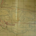
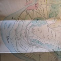
Original title (in French): Plan général du cours du Rhône de Lyon à Genève. English title: General map of the Rhône river from Lyon to Geneva.
- Auteur
- O'Brien
- Tags
- Fonds/Photographic fund
- Archives Nationales (France) (reference: F/14/6807)
- Contributeurs/Contributors
- Nature de la ressource/Resource type
- Map
- Date
- Période/Period
- 1845
- Commune/Municipality
- Secteur/Sector
- Genève to Lyon (208 km long)
- Echelle/Scale
- 1/180 000
- Lieu visé ou point de visée/Targeted place or photographer geolocation
- Projet OHM/OHM project
- Complément d'information/Additional information
- Ressource liée/Linked resource
- DOI
- Copyright
- Creative Commons (BY-NC)
- Make
- Canon
- Model
- Canon PowerShot G9
- DateTimeOriginal
- 2017:12:08 16:01:34
- ApertureFNumber
- f/4.0