
1129/1165
)
)
)
)
)
)
)
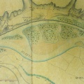
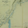
: Plan du Rhône et des latérales, rectifié visuellement, quant à l'état actuel des atterrissements du bras de Lavour. English title: Plan of the Rhône river and lateral lines, visually rectified, as to the current state of the deposits in the Lavour channel.")
Original title (in French): Plan du Rhône et des latérales, rectifié visuellement, quant à l'état actuel des atterrissements du bras de Lavour. English title: Plan of the Rhône river and lateral lines, visually rectified, as to the current state of the deposits in the Lavour channel.
- Auteur
- O'Brien
- Tags
- Fonds/Photographic fund
- Archives Nationales (France) (reference: F/14/6501)
- Contributeurs/Contributors
- Nature de la ressource/Resource type
- Map
- Date
- Période/Period
- 1835
- Commune/Municipality
- Secteur/Sector
- Chanaz, Lavours (3 km long)
- Echelle/Scale
- 1/5000
- Lieu visé ou point de visée/Targeted place or photographer geolocation
- Projet OHM/OHM project
- Complément d'information/Additional information
- Ressource liée/Linked resource
- DOI
- Copyright
- Creative Commons (BY-NC)
- Make
- Canon
- Model
- Canon PowerShot G9
- DateTimeOriginal
- 2017:04:05 07:30:43
- ApertureFNumber
- f/4.0