
264/297
)
)
)
)
)
)
)

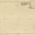
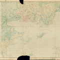
Plan de Petit-Bourg en 1733
- Auteur
- inconnu
- Mots-clés
- carte, histoire, Topographie
- Albums
- Fonds/Photographic fund
- ANOM - Archives nationales d'outre-mer
- Contributeurs/Contributors
- Nature de la ressource/Resource type
- Carte
- Date
- 1733
- Période/Period
- 1700-1799
- Commune/Municipality
- Petit-Bourg
- Secteur/Sector
- Petit Cul-de-Sac Marin
- Echelle/Scale
- Lieu visé ou point de visée/Targeted place or photographer geolocation
- lieu visé
- Projet OHM/OHM project
- Géohistoire 2017
- Complément d'information/Additional information
- Ressource liée/Linked resource
- http://anom.archivesnational
- DOI
- Copyright
- Creative Commons (BY-NC)