
Accueil / OHM Vallée du Rhône / Archives cartographiques et topographiques /
Map (Rhône delta, 1841-1865)
5/350
)
)
)
)
)
)
)
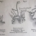
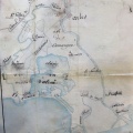
: Carte comparative des sondages opérés à l'embouchure du Rhône en 1841 et 1860. English title: Comparative map of surveys performed in the Rhône delta in 1841 and 1860.")
Original title (in French): Carte comparative des sondages opérés à l'embouchure du Rhône en 1841 et 1860. English title: Comparative map of surveys performed in the Rhône delta in 1841 and 1860.
- Auteur
- Erhard
- Tags
- Fonds/Photographic fund
- Bibliothèque Nationale de France (reference: Ge-FF.9127)
- Contributeurs/Contributors
- Nature de la ressource/Resource type
- Map
- Date
- Période/Period
- 1841-1865
- Commune/Municipality
- Secteur/Sector
- Rhône delta (16 km long)
- Echelle/Scale
- 1/12 000
- Lieu visé ou point de visée/Targeted place or photographer geolocation
- Projet OHM/OHM project
- Complément d'information/Additional information
- 2 maps
- Ressource liée/Linked resource
- DOI
- Copyright
- Creative Commons (BY-NC)