
Accueil / OHM Vallée du Rhône / Archives cartographiques et topographiques /
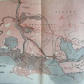
Map (Tarascon to Aiguemortes, 1833)
39/350
)
)
)
)
)
)
)
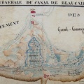
: Plan général des canaux concédés à la compagnie des canaux de Beaucaire et d'Aiguemortes et des propriétés qui lui appartiennent. English title: General plan of the canals granted to the Beaucaire and Aiguemortes canal company and the properties belonging to it.")
Original title (in French): Plan général des canaux concédés à la compagnie des canaux de Beaucaire et d'Aiguemortes et des propriétés qui lui appartiennent. English title: General plan of the canals granted to the Beaucaire and Aiguemortes canal company and the properties belonging to it.
- Auteur
- Talabot
- Tags
- Fonds/Photographic fund
- Archives Nationales (France) (reference: CP/F/14/10087/"Canal de Beaucaire". File 4-Piece 17)
- Contributeurs/Contributors
- Nature de la ressource/Resource type
- Map
- Date
- Période/Period
- 1833
- Commune/Municipality
- Secteur/Sector
- Tarascon to Aiguemortes (62 km long)
- Echelle/Scale
- 1/50 000
- Lieu visé ou point de visée/Targeted place or photographer geolocation
- Projet OHM/OHM project
- Complément d'information/Additional information
- Not entirely photographed
- Ressource liée/Linked resource
- DOI
- Copyright
- Creative Commons (BY-NC)