
Accueil / OHM Vallée du Rhône / Archives cartographiques et topographiques /
Map/Cross section (Camargue, 1845)
36/350
)
)
)
)
)
)
)
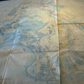
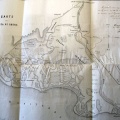
: Plan de la partie occidentale de la basse Camargue et du Levadon des Saintes Maries (...). English title: Map of the western part of the lower Camargue and the Levadon of Saintes Maries (...).")
Original title (in French): Plan de la partie occidentale de la basse Camargue et du Levadon des Saintes Maries (...). English title: Map of the western part of the lower Camargue and the Levadon of Saintes Maries (...).
- Auteur
- Ponts & Chaussées
- Tags
- Fonds/Photographic fund
- Archives Nationales (France) (reference: F/14/6537)
- Contributeurs/Contributors
- Nature de la ressource/Resource type
- Map/Cross section
- Date
- Période/Period
- 1845
- Commune/Municipality
- Secteur/Sector
- Camargue (33 km long)
- Echelle/Scale
- 1/50 000
- Lieu visé ou point de visée/Targeted place or photographer geolocation
- Projet OHM/OHM project
- Complément d'information/Additional information
- 2 maps and cross sections
- Ressource liée/Linked resource
- DOI
- Copyright
- Creative Commons (BY-NC)