
Accueil / OHM Vallée du Rhône / Archives cartographiques et topographiques /
Map (Beaucaire to the sea, Late 18th c.)
20/350
)
)
)
)
)
)
)
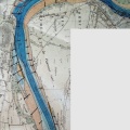
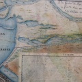
: Carte des marais et de la plaine depuis Beaucaire jusqu'à Aiguemortes où l'on a tracé les parties du canal de navigation déjà faites et celles qui restent à faire jusqu'à Beaucaire pour le joindre avec le Rhône. English title: Map of the marshes and the plain from Beaucaire to Aiguemortes where the parts of the navigation canal already completed and those that remain to be done up to Beaucaire to join it with the Rhône river have been traced.")
Original title (in French): Carte des marais et de la plaine depuis Beaucaire jusqu'à Aiguemortes où l'on a tracé les parties du canal de navigation déjà faites et celles qui restent à faire jusqu'à Beaucaire pour le joindre avec le Rhône. English title: Map of the marshes and the plain from Beaucaire to Aiguemortes where the parts of the navigation canal already completed and those that remain to be done up to Beaucaire to join it with the Rhône river have been traced.
- Auteur
- Delisle
- Tags
- Fonds/Photographic fund
- Archives Nationales (France) (reference: CP/F/14/10087/"Canal de Beaucaire". File 4-EN°7)
- Contributeurs/Contributors
- Nature de la ressource/Resource type
- Map
- Date
- Période/Period
- Late 18th c.
- Commune/Municipality
- Secteur/Sector
- Beaucaire to the sea (56 km long)
- Echelle/Scale
- ~ 1/100 000
- Lieu visé ou point de visée/Targeted place or photographer geolocation
- Projet OHM/OHM project
- Complément d'information/Additional information
- Ressource liée/Linked resource
- DOI
- Copyright
- Creative Commons (BY-NC)