
Accueil / OHM Vallée du Rhône / Archives cartographiques et topographiques /
Map/Cross section/Long profile/Slope table (Lyon to the sea, 1822-1824)
8/350
)
)
)
)
)
)
)
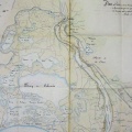
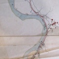
: Projet de canal latéral au Rhône. English title: Project for a lateral canal to the Rhône river.")
Original title (in French): Projet de canal latéral au Rhône. English title: Project for a lateral canal to the Rhône river.
- Auteur
- Cavenne, District engineers
- Tags
- Fonds/Photographic fund
- Archives Nationales (France) (reference: CP/F/14/10122/1/pieces1-2, CP/F/14/10122/3/piece1, CP/F/14/10122/6-7-9-11, CP/F/14/10122/4/pieces4-5-6-22-23-24-25-26)
- Contributeurs/Contributors
- Nature de la ressource/Resource type
- Map/Cross section/Long profile/Slope table
- Date
- Période/Period
- 1822-1824
- Commune/Municipality
- Secteur/Sector
- Lyon to the sea (323 km long)
- Echelle/Scale
- 1/10 000-1/91 000
- Lieu visé ou point de visée/Targeted place or photographer geolocation
- Projet OHM/OHM project
- Complément d'information/Additional information
- 5 map series, 2 table/cross section/long profile series of the canal area. Not entirely photographed
- Ressource liée/Linked resource
- DOI
- Copyright
- Creative Commons (BY-NC)