
Accueil / OHM Vallée du Rhône / Archives cartographiques et topographiques /
Map (Arles to the sea, 1844)
7/350
)
)
)
)
)
)
)
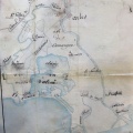
: Plan du Rhône et de ses chaussées, dans la 4ème section du fleuve, pour être joint aux projets de rehaussement des dites chaussées. English title: Plan of the Rhône river and its roadways, in the 4th section of the river, to be attached to the roadway raising projects.")
Original title (in French): Plan du Rhône et de ses chaussées, dans la 4ème section du fleuve, pour être joint aux projets de rehaussement des dites chaussées. English title: Plan of the Rhône river and its roadways, in the 4th section of the river, to be attached to the roadway raising projects.

- Auteur
- Ponts & Chaussées
- Tags
- Fonds/Photographic fund
- Archives Nationales (France), Archives Départementales du Rhône (reference: F/14/6585, 3959 W 1726)
- Contributeurs/Contributors
- Nature de la ressource/Resource type
- Map
- Date
- Période/Period
- 1844
- Commune/Municipality
- Secteur/Sector
- Arles to the sea (51 km long)
- Echelle/Scale
- 1/50 000
- Lieu visé ou point de visée/Targeted place or photographer geolocation
- Projet OHM/OHM project
- Complément d'information/Additional information
- Ressource liée/Linked resource
- DOI
- Copyright
- Creative Commons (BY-NC)