
Accueil / OHM Vallée du Rhône / Archives cartographiques et topographiques /
Long profile (Anglefort to Chanaz, 1863)
70/350
)
)
)
)
)
)
)
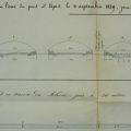
: Profil en long de la crue de 1863 dans la traversée de la plaine de la Chautagne, sur la rive gauche du Rhône. English title: Long profile of the 1863 flood in the Chautagne plain on the left bank of the Rhône river.")
Original title (in French): Profil en long de la crue de 1863 dans la traversée de la plaine de la Chautagne, sur la rive gauche du Rhône. English title: Long profile of the 1863 flood in the Chautagne plain on the left bank of the Rhône river.
- Auteur
- Kleitz
- Tags
- Fonds/Photographic fund
- Archives Départementales du Rhône (reference: 3959 W 1744)
- Contributeurs/Contributors
- Nature de la ressource/Resource type
- Long profile
- Date
- Période/Period
- 1863
- Commune/Municipality
- Secteur/Sector
- Anglefort to Chanaz (13 km long)
- Echelle/Scale
- 1/20 000
- Lieu visé ou point de visée/Targeted place or photographer geolocation
- Projet OHM/OHM project
- Complément d'information/Additional information
- Ressource liée/Linked resource
- DOI
- Copyright
- Creative Commons (BY-NC)