
58/350
)
)
)
)
)
)
)
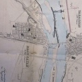
: Amélioration de la navigation entre les roches de Tête-Noire et le pont de Rochemaure. English title: Navigation improvement between the Tête-Noire rocks and the Rochemaure bridge.")
Original title (in French): Amélioration de la navigation entre les roches de Tête-Noire et le pont de Rochemaure. English title: Navigation improvement between the Tête-Noire rocks and the Rochemaure bridge.
- Auteur
- Kleitz
- Tags
- Fonds/Photographic fund
- Archives Nationales (France) (reference: F/14/6570)
- Contributeurs/Contributors
- Nature de la ressource/Resource type
- Map
- Date
- Période/Period
- 1860
- Commune/Municipality
- Secteur/Sector
- Rochemaure (8,5 km long)
- Echelle/Scale
- 1/10 000
- Lieu visé ou point de visée/Targeted place or photographer geolocation
- Projet OHM/OHM project
- Complément d'information/Additional information
- Ressource liée/Linked resource
- DOI
- Copyright
- Creative Commons (BY-NC)