
Accueil / OHM Vallée du Rhône / Archives cartographiques et topographiques /
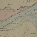
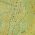
Map/Cross section (Vallabrègues to Beaucaire, 1855)
57/350
)
)
)
)
)
)
)
: Constitution d'un syndicat pour la défense des propriétés intéressées à l'existence de la chaussée de la Montagnette. English title: Constitution of a syndicate for the defence of properties interested in the Montagnette roadway.")
Original title (in French): Constitution d'un syndicat pour la défense des propriétés intéressées à l'existence de la chaussée de la Montagnette. English title: Constitution of a syndicate for the defence of properties interested in the Montagnette roadway.
- Auteur
- Kleitz
- Tags
- Fonds/Photographic fund
- Archives Départementales du Rhône (reference: 3959 W 1720)
- Contributeurs/Contributors
- Nature de la ressource/Resource type
- Map/Cross section
- Date
- Période/Period
- 1855
- Commune/Municipality
- Secteur/Sector
- Vallabrègues to Beaucaire (8 km long)
- Echelle/Scale
- 1/10 000
- Lieu visé ou point de visée/Targeted place or photographer geolocation
- Projet OHM/OHM project
- Complément d'information/Additional information
- Ressource liée/Linked resource
- DOI
- Copyright
- Creative Commons (BY-NC)