
Accueil / OHM Vallée du Rhône / Archives cartographiques et topographiques /
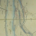
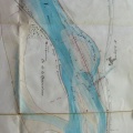
Map (Pierre-Bénite, 1863)
47/350
)
)
)
)
)
)
)
: Plan de la lône de Pierre-Bénite. English title: Plan of the abandoned channel at Pierre-Bénite .")
Original title (in French): Plan de la lône de Pierre-Bénite. English title: Plan of the abandoned channel at Pierre-Bénite .
- Auteur
- Kleitz
- Tags
- Fonds/Photographic fund
- Archives Nationales (France) (reference: F/14/6707)
- Contributeurs/Contributors
- Nature de la ressource/Resource type
- Map
- Date
- Période/Period
- 1863
- Commune/Municipality
- Secteur/Sector
- Pierre-Bénite (4 km long)
- Echelle/Scale
- 1/5000
- Lieu visé ou point de visée/Targeted place or photographer geolocation
- Projet OHM/OHM project
- Complément d'information/Additional information
- Ressource liée/Linked resource
- DOI
- Copyright
- Creative Commons (BY-NC)